Time between two dates with time zone
To calculate number of days, hours, minutes and seconds between two dates with time zones.
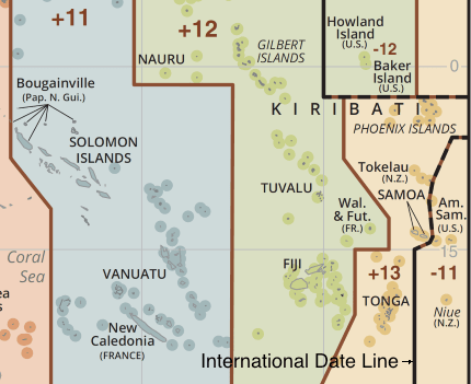
The calculator below gives a time difference in years, months, days, hours, minutes, and seconds between two time points of two different Earth locations. As an example, I choose a new 2019 year moment on two islands in the Pacific ocean. Even though the islands are 45 miles, the time there is 25 hours apart in the summer. To find out why this is so, read the article immediately below the calculator.
Brief explanation.
The Earth is divided into several zones where time differs. Usually, time in adjacent zones differs by one hour, with increments from west to east, except in special cases when the outer zones meet each other. A border between outer time zones is called the International date line. The time of the zones laying on both sides of the International date line differs by one day.

The International date line goes just between the island from the example mentioned above, so the time in these islands differs by 24 or 25 hours (one hour is added by Daylight saving time used in Samoa in summer).
History.
Before the 19th century, each country and even each city in the same country kept its time based on local mean time. The local mean time keeps a uniform time scale for a given longitude only. So the time varied from place to place, even in the same country.
United States regions time offsets from GMT (19th century vs. current time)
| City | 19th century (LMT) | Jan, 1st, 2019 |
|---|---|---|
| New York | -04:56:02 | -05:00 |
| Detroit | -05:32:11 | -05:00 |
| Monticello, Kentucky | -05:39:24 | -05:00 |
| Vevay, Indiana | -05:40:16 | -05:00 |
| Louisville, Kentucky | -05:43:02 | -05:00 |
| Indianapolis | -05:44:38 | -05:00 |
| Marengo, Indiana | -05:45:23 | -05:00 |
| Winamac, Indiana | -05:46:25 | -05:00 |
| Knox, Indiana | -05:46:30 | -06:00 |
| Tell City, Indiana | -05:47:03 | -06:00 |
| Petersburg, Indiana | -05:49:07 | -05:00 |
| Vincennes, Indiana | -05:50:07 | -05:00 |
| Menominee, Michigan | -05:50:27 | -06:00 |
| Chicago | -05:50:36 | -06:00 |
| Center, North Dakota | -06:45:12 | -06:00 |
| Beulah, North Dakota | -06:47:07 | -06:00 |
| Denver | -06:59:56 | -07:00 |
| Phoenix | -07:28:18 | -07:00 |
| Boise, Idaho | -07:44:49 | -07:00 |
| Los Angeles | -07:52:58 | -08:00 |
It was hard for railway companies to make different timetables in local times for every town on the route. Worldwide navigation was another problem that demanded single world time. During International Meridian Conference, which is held in the United States in 1884, most of the participated countries have chosen the Greenwich meridian as an initial meridian for longitude and decided "to adopt a universal day for all purposes for which it may be found convenient, which is to begin for all the world at the moment of mean midnight of the initial meridian, coinciding with the beginning of the civil day and date of that meridian; This universal day is to be a mean solar day; and is to be counted from zero up to twenty-four hours". The process of introducing GMT-based time in the world lasted for decades.
In the 20th century, Greenwich Mean Time (GMT) was replaced by more accurate Coordinated Universal Time (UTC), which is counted by an atomic clock and corrected manually from time to time to make it closer to the based on Earth's rotation universal time on the zero degree meridian. Modern time zone time offsets are counted from UTC, e.g., UTC+03, UTC-06.
Time zone offsets and boundaries.
A time zone offset is generally an integer number of hours from -12 to +14, but few territories have the time offset rounded to 30 minutes or even 15 minutes. The table below shows the zones with non-integer offset:
| Territory | Offset |
|---|---|
| Marquesas Islands | -09:30 |
| Canada, Newfoundland | -03:30 |
| Iran | +03:30 |
| Afganistan | +04:30 |
| India Sri Lanka |
+05:30 |
| Nepal | +05:45 |
| Myanmar Cocos Islands |
+06:30 |
| Australia | +08:45, +09:30, +10:30 |
| Lord Howe Island | +10:30 |
| New Zealand, Chatham Island | +12:45 |
Time zone boundaries are quite complex because they often reflect country or district borders. Moreover, the time zone boundaries may change over time due to state borders changes or government decisions.
Daylight saving time
Some countries advance their clocks in spring by one hour and set it back in autumn. This advanced by one hour time is called Summer time or Daylight saving time (DST) or simply Daylight time. It is used for more rational use of daylight hours and to save electricity for lighting. There are different rules for switching the DST time on or off in different countries. Recently some countries decided to abandon DST due to complexity and not proven benefits.
The calculator uses a timezone database, which keeps records of DST and other time changes in every region since 1970th and from earlier times for most popular territories.
Comments